Izta & Orizaba
- Admin
- Mar 1, 2021
- 9 min read

December 2020, Mexico - Few people outside of the climbing community are aware that Mexico is home to some of the highest mountains in North America and largest volcanoes on earth. Among them are Pico de Orizaba, Popocatepetl, and Iztaccihuatl—each part of the Pacific’s Ring of Fire and the third, fifth, and eighth highest peaks on the continent respectively. In December of 2020 I made a quick trip to Mexico to escape the wintery confines of Seattle with my friend Bert who I met while climbing Denali in the summer of 2019.
Popocatepetl, pronounced “po-po-kah-TAPE-etl” or simply “Popo” is located a few hours south east of Mexico City and is presently active, erupting more than twice daily. The mountain has been closed to climbing for several years, and for good reason, as the peak spews large plumes of rock and dust high into the atmosphere. While I hope to visit Popo in the future once its activity settles down, mine and Bert’s objectives were Iztaccihuatl (pronounced “ees-tah-SEE-watl” or “ees-tah” for short) and Pico de Orizaba (pronounced “PEE-ko day oh-ree-SAH-bah”).

Izta, the oldest of the three peaks and visibly more eroded, is characterized by a super long summit ridge running north to south. Situated just a few miles north of Popo, locals call the mountain “The Sleeping Woman” as when viewed from the east or west the various summits mimic the head, chest, and knees of a woman sleeping on her back. Bert and I took an Uber from the heart of Mexico City to the park headquarters where we met up with our guide Christian. After a bumpy drive up a dirt road we made it to our basecamp at 12,000 feet just as the sun began to set, the light refracting through Mexico City’s air pollution and bathing Izta a beautiful deep purple and red. I slept horribly that night, having traveled from sea level on a red eye flight just the day before.
"Keep moving, keep moving…or he’ll leave your ass here"
Our first day on the mountain was a quick training hike up the grassy lower slopes. While the hike was not too long or difficult, it revealed my lack of acclimatization and exposed my substandard level of fitness (at least by my standards). I was a little shaken after the hike, sucking a lot more wind than I expected to on this amuse-bouche before our entrée and summit push the following day.
After a small dinner and another restless night, we awoke at around 1:30 AM and drove a short distance to the trailhead. The first few hours of the route were on a standard trail, switch-backing up the slope through bushy blonde grasses. I was feeling the altitude and was moving slowly but purposefully. After our first rest break we ascended into a thick mist and a fine layer of ice started to form on my backpack and clothes as we left all plant and other lifeforms behind at lower altitudes. Our guide Christian was a quiet guy who spoke little English and led the way around 50 to 100 feet ahead of Bert and me. It was a more distant client-guide relationship than I was used to but motivating in its own way to see him so far out front. Keep moving, keep moving…or he’ll leave your ass here.

At the “feet” on the southern edge of the route, the trail crossed from the west side of the ridge to the east and steepened as the compact trail turned into sandy scree. We took another rest break and then ascended a steep rock band to the apex of the ridge above the frozen mist, the glow from Mexico City now visible off in the distance.
The route got even steeper as we climbed the physical crux of the route towards the first false summit of “the knees”. Until this point the climbing had been on a well-established trail that was more or less a normal hike at significant altitude. Climbing this portion of Izta, however, involved some class three moves and the use of hands that required me to stow my trekking poles between the small of my back and my backpack.
"Finally, I made it to the top, and for the first time in my mountaineering career I was simply too tired to care"
After an hour of climbing on this more technical terrain we made it to the first false summit just as the sun started to crest over the horizon. The views below us were tremendous, especially that of Popo erupting behind us just a few miles to the south.

We donned crampons and crested a small false summit to access the only glaciated terrain on the route, descending a steep section of hard ice to a large saddle along the summit ridge. With the true summit in sight, but still an hour or more away, I was starting to slow down significantly. It was clear at this point that my training was borderline adequate and level of acclimatization far from where it needed to be. For the first time in a long while, I was completely redlined and working at 100% effort to put one slow and deliberate foot in front of the other. With Bert ahead of me I had no doubt about making the summit, but some trepidation started to creep into my mind knowing we planned to climb an even higher mountain in just two days’ time.

Step, step, gasp! Step, step, gasp! Slowly but surely, I plodded my way up the final slope, swearing off mountaineering along the way. I could see Bert standing atop Izta and I took another few minutes to catch up to him. Finally, I made it to the top, and for the first time in my mountaineering career I was simply too tired to care.
“Thank god we’re here,” I said to Bert. “I had maybe another 10 minutes in me maximum.”
After a few snacks and sips of water I started to recover and take in the scene before me. The various false summits of Izta to the south were framed by the steaming heap of volcanic rock and rubble that is Popocatepetl. Well above the clouds, we could see the symmetrical mass of Pico de Orizaba some 180 miles to the east. It looked big. REALLY big!
"Exhausted from our climb, our guide drove for hours down a narrow lane, our bones, muscles, and patience shaken to bits"
We descended the undulating ridge, climbing up nearly as much as down until reaching the “feet” of the sleeping woman. After more than 12 hours of hard effort we made it back to the trailhead parking lot and I sighed with relief as I peeled my boots off. Exhausted from one of the hardest days I’d had in the mountains, I was doubtful that I would be in good enough shape to attempt Orizaba in less than 48 hours. Bert gave me a little pep talk and I agreed to see how I felt the next day before deciding to throw in the towel or go for it.
Unbeknown to us, the drive from Izta to our hotel in the city of Puebla followed what I must imagine is the longest and bumpiest dirt road in Mexico. Of course, I am being hyperbolic with this description, but it was a truly endless drive. Exhausted from our climb, our guide drove for hours down a narrow lane, our bones, muscles, and patience shaken to bits. I tried to soak it in as part of the adventure, but both Bert and I were pretty fed up with it by the time we finally hit pavement and started to make our way back into civilization.
After a restful night’s sleep in Puebla, which is a really fantastic little city, we met our guide Oscar who would accompany us up Pico de Orizaba. I was feeling refreshed at the lower altitudes and amazed by how much better I felt than the day before. As such, I decided that I would make the attempt up Orizaba with Bert.

The drive to the mountain from Puebla was another few hours to the east, but thankfully on much better roads and in the comfort of a newer sedan with AC. On the drive, we saw Orizaba poking out above the clouds some fifty miles away. It was a hulking symmetrical volcanic mass and I got that wonderfully uncomfortable feeling in the pit of my stomach that only a large mountain can induce within me. We arrived at the small village of Miguel Hidalgo on the slopes of Orizaba in the late afternoon, just in time for Bert to take an acclimatization hike to a waterfall and for me to take a nap. At dinner we performed a gear check with Oscar in the bunkhouse and got everything packed and organized for a 12:30 AM wake-up where we would take an old 4x4 up an even bumpier dirt road from the village to the trailhead.
It was impressive watching the driver navigate the dirt road, grooved and rutted all over, in his 1997 Chevy Suburban. It was clear this was not the driver’s first rodeo as all the while he was chatting with Oscar in the front seat about what his mechanic told him about his truck’s alternator, the meteor shower that was supposed to happen that night, and somebody from Mexico City who just purchased a parcel of land next to his house. While it was just another day at the office for the driver and for Oscar, Bert and I were getting mentally prepared for another long day in the alpine.
When we made it to the trailhead, it was an inky black night with not a breath of wind. Now that it was “go time” my doubts from the days prior melted away and I was ready to take on Orizaba.


The lower part of the route was a loosely established hiking trail, following an aqueduct and gentle switch-backs to the base of the glacier on the upper slopes. After 90 minutes of slow but steady climbing, we made it a rocky section called “The Labyrinth” and I was very glad to have Oscar with us, as wayfinding through this portion of the route was especially difficult. Ascending hard ice and snow between large boulders, it would be all too easy to lose the route in this section and spend hours waiting for the sun to rise to get re-oriented. Fortunately, Oscar was close to completing his two-hundredth summit of the mountain and steered us through this section with his eyes closed.
We arrived at the base of the glacier just before sunrise. It was cold and the wind had picked up substantially, cutting through my layers and chilling me to the bone as I did my best to scarf down a snack. These are the moments when it’s easy to say, “Why do I subject myself to this!? I’m on vacation after all and could be on a beach somewhere!” But who am I kidding, these are the moments I live for.


Oscar, Bert, and I roped up in the early morning light and started to make our way up the glacier. At this point the route to the summit was entirely visible and could see a string of climbers above us, some close, and some maybe 1-2 hours ahead. Most climbers were following an established climbing trail to climber’s right, but we opted for a slightly less steep option to the left. This had the added benefit of not subjecting us to the risk of climber’s falling on top of us from above and gave us the ability to work different muscle groups by making switch-backs every so often instead of a direct vertical ascent.
The slope angle got steeper and steeper as we climbed higher and both Bert and I started to slow down as the effects of high altitude became more and more acute. We took two breaks on the glacier, the last of which was a brief respite where the angle of the slope was so great that we were unable to take off our backpacks.
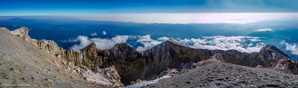
The summit was near, and I could see that we were rapidly approaching the crater rim. Taking deep breaths and moving one foot at a time, we stepped out of shadow and into the sunlight on the crater rim of Orizaba. The true summit was still another 100 vertical feet above us to the west, so we kept moving upward, taking in the view of the crater and surrounding landscape many thousands of feet below. There was a small crowd gathered on the true summit and after a few minutes of climbing we had made it to the top of Pico de Orizaba, the tallest volcano in North America and third highest point on the continent.

It had been a hard few day of travel and climbing, and I was surprised when tears welled up in my eyes. It was a powerful moment for me, given the physical and mental hardship of both Izta and Orizaba in such quick succession. I was proud of myself and grateful for the opportunity to be in this incredible place: the shadow of this massive mountain cast on the landscape below me, the Gulf of Mexico almost visible in the east, and the erupting Popo to the west. By summiting Orizaba, Bert and I both had stood on the highest and third highest points in North America. It was mission accomplished, for now.
What mountain is next, and when will that be?


Comments